• Knowledge
SupportSupport
  • Deutsch
  • Svenska
  • Forestry

    Icebound Forest offers a complete product suite covering nearly the entire raw materials process—from forest management planning through production and procurement support, road management, to log yard logistics.
  • Infrastructure

    Icebound supports you in planning, tracking, and analyzing mobile resources. In our ProLocate Suite, you’ll find solutions for: road maintenance, landscaping, sewer cleaning, and graffiti removal.
  • Mining

    For those in the mining industry, we offer essential GIS products for the entire organization, as well as the industry’s best mapping services—Icebound Maps
  • Energy

    For those in the energy sector, we offer essential GIS products for your entire organization, as well as the industry’s best mapping services—Icebound Maps
  • GIS & Geodata

    Icebound Maps - Sweden's best mapping services! We provide our own GIS platform, AddSpatial, and are also strong partners with ESRI, Preciseley, and Google
    • View all products
    • pcSKOG
    • ForestPlan
      • Optional: Budget
      • Optional: Arboreal
      • Assessment of Natural Value
    • TimberTrack
      • Production Planning
      • Entrepreneur
      • Timbertrail
      • Log Landing
      • Assessment of Natural Value
    • Efficture Virke
      • Efficture Forest Owner Portal
    • Fastighet och Avtal
    • GPS Timber
      • Dynamic Sorting
    • Vägrapport
    • ProLocate RMS
    • Maps, Geographic/Property Data
    • ProLocate
      • Vinterväg
      • Grönyta
      • Slam
    • Vägrapport
    • ProLocate RMS
    • Maps, Geographic/Property Data
    • AddSpatial GIS
    • ProLocate
    • Maps, Geographic/Property Data
    • AddSpatial GIS
    • Map/Property Data
    • ProLocate
    • Icebound Maps
      • Bakgrundskartor
      • Verksamhetskartor
      • Maps – API:er
    • FastighetDirekt
    • Fastighetsdatabas
    • AddSpatial GIS
    • KartSmart
    • MapInfo
    • ArcGIS platform
    • Google Maps Platform
    • AddSpatial Platform

    View all products

    View our entire product catalog
  • Icebound Forest

    A Complete Product Line for the Forest
  • Maps, Geographic/Property Data

    Maps and Property Data
  • ProLocate

    Improved Field Production
  • AddSpatial Platform

    Modern GIS Platform
    • News / Press / Media

      Here you can read the latest news about us and our mission...
    • Contact

      We always want to be available to you. Here you'll find the most common ways to contact us, addresses, and more...
    • Support and Customer Service

      If you have a support contract or would like to learn more, click here...
    • Operational Information

      Here you can read about planned and ongoing service disruptions...
    • About Us & Our History

      We at Icebound are proud of our long and continuous history dating back to the 1990s. Read more here...
    • Career

      Icebound is always looking for our next team members. If you're interested in applying, read more...
    • Documents

      Here you'll find various types of policy documents related to our operations...
    • Partnerships & Growth

      We are strong, but we aim to become even bigger and better. We will achieve this through alliances and acquisitions. Read more here...
    • Sustainability & Quality

      We make a difference by providing technology and supporting others who are also making the world a better place...
    • Icebound AddSpatial

      As a customer, you can log in to your AddSpatial account here. AddSpatial is Icebound's proprietary online GIS platform for both our products and customer solutions.
    • Icebound Forest

      As a customer of Icebound Forest, you can log in to your account here. Icebound Forest, a leading provider of IT support for the forestry industry.
    • Icebound ProLocate

      As a customer of the ProLocate suite, you can log in to your account here. Icebound ProLocate—leading solutions for the construction industry.
      • Forestry
      • Infrastructure
      • Mining
      • Energy
      • GIS & Geodata
        • pcSKOG
        • ForestPlan
        • TimberTrack
        • Efficture Virke
        • Fastighet och Avtal
        • GPS Timber
        • Vägrapport
        • ProLocate RMS
        • Maps, Geographic/Property Data
        • ProLocate
        • Vägrapport
        • ProLocate RMS
        • Maps, Geographic/Property Data
        • AddSpatial GIS
        • ProLocate
        • Maps, Geographic/Property Data
        • AddSpatial GIS
        • Map/Property Data
        • ProLocate
        • Icebound Maps
        • FastighetDirekt
        • Fastighetsdatabas
        • AddSpatial GIS
        • KartSmart
        • MapInfo
        • ArcGIS platform
        • Google Maps Platform
        • AddSpatial Platform
      • All Products
      • Icebound Forest
      • Maps, Geographic/Property Data
      • ProLocate
      • AddSpatial Platform
    • Knowledge
      • News / Press / Media
      • Contact
      • Support and Customer Service
      • Operational Information
      • About Us & Our History
      • Career
      • Documents
      • Partnerships & Growth
      • Sustainability & Quality
    • Support
    • English Deutsch Svenska

    ESUDA – Energy Savings through the Smart Use of Data

    Icebound is participating in the ESUDA research project, which aims to contribute technologies and methods to reduce energy consumption in smart buildings and cities.

    Maps & 3D Visualization for Better Analysis

    We lack systems, products, and services that enable the optimization of energy use in society. The ESUDA project aims to develop innovations that analyze and then control and optimize energy use in buildings and cities. Digital twins of buildings and cities make the analysis and subsequent control simpler and more efficient. This is where Icebound comes in!

    Our Challenge

    We want to establish an innovation environment for digital transformation in society focused on reducing energy consumption. We are demonstrating the potential of artificial intelligence and machine learning (AI/ML) methods for digital development—specifically in the area of building automation in this project—but the insights gained in the public sector and industry are also expected to contribute to their application in other areas.

    We want to achieve

    The project aims to develop innovations for analyzing the energy needs of buildings under various conditions by using historical data that takes into account weather conditions, building information, and building occupancy. This data is used to predict future energy needs in buildings, to balance energy demand across buildings, and to reduce overall energy consumption.

    Icebound contributes to a more sustainable society

    The various project partners in the energy sector are working hard to collect data from sensors and measurement points throughout buildings in the participating locations. Together, they are developing models and control methods to optimize energy use.
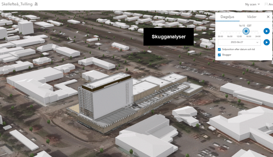
    Image: Example of a BIM model—Sara Kulturhus in Skellefteå—presented in a geographic context, with opportunities for analysis and further work.

    To facilitate and enable effective analyses, the project has chosen to work with digital twins at the building and city levels.

    “Using technology from our partner ESRI, we can design and maintain digital twins. We work to create a 3D GIS geographic model from CAD and BIM formats (which involve the creation and use of a 3D digital model of a structure). These models can then be used specifically for simulations, analyses, and to simplify maintenance work. In this case, for example, heat sensors, airflow, water and sewer systems, and other systems. “— says Anders Haraldsson, Project Manager at ESUDA Icebound

    The subject area for this type of solution/technology is called AEC-O (Architecture, Engineering, Construction, and Operations).

    Would you like to learn more about how Icebound works to conduct research-based development and contribute to a more sustainable society?

    Contact Anders Haraldsson, Marketing Manager and Project Manager for ESUDA at Icebound – anders.haraldsson@icebound.com

    About ESUDA

    ESUDA is a project funded by the EU Regional Development Fund. It is also co-funded by some of the project’s participants, such as: the Västerbotten & Norrbotten Region, the municipalities of Skellefteå and Piteå, Luleå University, CGI, Icebound, Dataductus, and Leosol. Together, we are developing a platform on which other companies are welcome to build solutions.

    Learn more about the ESUDA project at: https://esuda.se/

    The project uses

    ArcGIS platform

    ArcGIS – The professional GIS platform from ESRI
    GIS/Geodata

    Icebound is an IT company that provides products and e-services that digitize our customers’ businesses and make them more sustainable. We specialize in Geographic Information Systems (GIS) and digital mapping.

    Drawing on our many years of experience and our innovative team, we help customers in the basic industries—primarily the forestry sector—in Sweden and internationally to operate efficiently and make the right decisions.

    Icebound is part of the Addnode Group (listed on Nasdaq Stockholm). For more information, visit: www.addnodegroup.com

    \Icebound AB has been certified under FR2000 since its founding in 2024. Read more!

    Sign up for our newsletter

    Thank you!

    Industries
    Forestry Infrastructure Mining Energy GIS & Geodata
    Our Products
    Suites Products
    The Company
    About Us & Our History Contact ESUDA – Icebound Participates in Research Project News / Press / Media Partnerships & Growth Sustainability & Quality Documents Career Support and Customer Service

    Phone

    +46 771 19 19 95

    Email

    info@icebound.com

    Address

    28C Storgatan, 921 31, Lycksele

    Policy

    Cookie Policy Website Privacy Policy