
 Support

Icebound Maps
The National Heritage Board
The National Heritage Board
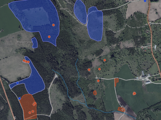
The National Heritage Board is a unified vector map consisting of three different layers. The various layers represent all of the country’s archaeological and cultural sites as points, lines, and vectors.
All included sites are classified and visualized as follows: Archaeological Site, Possible Archaeological Site, Other Cultural-Historical Site, No Archaeological Assessment, and Non-Cultural-Historical Site.
Contains data from: The Swedish National Heritage Board
NOTE: Background map not included.
Click below for a demo!
Frequency: Updated 4 times a year
Delivery format:
- WMS 1.1.1/1.3.0 with GetFeatureInfo (info click) for each included layer.


Icebound is an IT company that provides products and e-services that digitize our customers’ businesses and make them more sustainable. We specialize in Geographic Information Systems (GIS) and digital mapping.
Drawing on our many years of experience and our innovative team, we help customers in the basic industries—primarily the forestry sector—in Sweden and internationally to operate efficiently and make the right decisions.
Icebound is part of the Addnode Group (listed on Nasdaq Stockholm). For more information, visit: www.addnodegroup.com
Icebound AB has been certified under FR2000 since its founding in 2024. Read more!